Caves and seabeds of Maratea
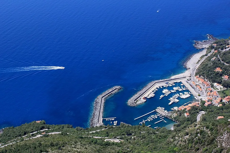
Thirty kilometres of high, jagged coast, with dozens of sea caves, black-sand coves and the islet of Santo Janni: by kayak you paddle into the caves, underwater you see walls teeming with life.
The story
Hundreds of fragments of Roman amphorae have been found around the island of Santo Janni: there was a fish-processing works here making garum, the Romans' fish sauce. Above the coast, on Monte San Biagio, the statue of the Redeemer, more than 20 metres tall, looks out over the gulf.
Why go
Because it is the wildest stretch of the Tyrrhenian between Campania and Calabria, with crystal-clear water.
Which wind
Good with Calm sea, light Tramontana
Avoid with Maestrale, Libeccio
Practical information
- Activities
- Kayaking, Snorkelling, Scuba diving
- Level
- Beginners (kayaking and snorkelling), basic certification (diving)
- Seabed
- Limestone cliffs, caves, shoals and Posidonia
- Best time
- June–September
- Seasons
- Summer
- Getting there
- Kayak rentals and dive centres at Maratea harbour and Fiumicello.
Get directions ↗Marine reserve rules
Saved. You'll find everything in My trip, where you can split it into days and see it on the map.
Saved on this device: you can open it even without a connection. All your saved pages are in Offline guides.
Weather and sea forecast
The forecast for the next 7 days at this spot: sky, temperatures, rain and wind, wave height and sea temperature.
Forecast by Open-Meteo (CC BY 4.0), from the models of national weather services. Your browser downloads it directly from Open-Meteo, and only when you ask. In the mountains and at sea the weather changes quickly: check the official forecast as well before you set off.
Getting there
- By train. The nearest station is Maratea station, 1.6 km away (about 30 minutes on foot). Alternatively: Marina di Maratea station, 3.1 km away.
- By air. The nearest airport is Salerno Airport (QSR), about 98 km away; with more flights, Bari Airport (BRI) is about 156 km away.
- Parking. The nearest public car park is 1.2 km away.
Stations, ports, airports and car parks from OpenStreetMap (© OpenStreetMap contributors, ODbL); distances as the crow flies. Timetables and connections change: check them before you travel.
Climate and sea month by month
The most pleasant months for weather are from April to June and from September to November, with average highs between 18 and 29 °C. From July to August it is hot: average highs exceed 30 °C. The wettest month is November (about 135 mm), the driest July. The sea is above 22 °C from June to October, peaking at 28 °C in August.
| Month | Temperature | High / low | Rain mm | Sea |
|---|---|---|---|---|
| Jan | from 8 to 14 °C | 14° 8° | 118 | 16° |
| Feb | from 9 to 15 °C | 15° 9° | 111 | 15° |
| Mar | from 9 to 16 °C | 16° 9° | 81 | 15° |
| Apr | from 12 to 18 °C | 18° 12° | 49 | 16° |
| May | from 16 to 22 °C | 22° 16° | 61 | 19° |
| Jun | from 20 to 27 °C | 27° 20° | 31 | 24° |
| Jul | from 24 to 31 °C | 31° 24° | 21 | 27° |
| Aug | from 24 to 31 °C | 31° 24° | 40 | 28° |
| Sep | from 20 to 27 °C | 27° 20° | 67 | 26° |
| Oct | from 17 to 24 °C | 24° 17° | 95 | 23° |
| Nov | from 14 to 20 °C | 20° 14° | 135 | 20° |
| Dec | from 10 to 16 °C | 16° 10° | 82 | 18° |
Averages for 2015–2024, estimated for an altitude of 0 m. Air: NASA POWER (MERRA-2 reanalysis), corrected for the altitude of the place; rain: average monthly total; sea: surface temperature from NOAA OISST. These are indicative values: the weather on any given day can be very different, so always check the forecast before you go.
In the guide
Other spots nearby
- ★ SUP and kayaking on the Ionian coast at MetapontoSUP, Kayaking · 104 km
- Monticchio LakesKayaking, Lake swimming · 106 km
Sea conditions can change within hours: before going in, check the marine forecast and the local harbour office (Capitaneria di porto) rules. Emergencies at sea: 1530.